
Controversy Over Resting Spot of Noah’s Ark May Finally Be Put To The Test
November 15, 2023
From Prophecy News Watch
Reprinted from Prophecy News Watch & Israel 365 News
VIDEO
A team from Istanbul Technical University (İTÜ) and Ağrı İbrahim Çeçen University (AİÇÜ) has been researching an area in which they believe lie the remains of Biblical Noah’s Ark.
A research team from Istanbul Technical University (İTÜ), Andrew University, and Ağrı İbrahim Çeçen University (AİÇÜ) carried out its first study of the site in December 2022. The group, which included academics specialized in geophysics, chemistry and geoarchaeology research, collected 30 samples consisting of soil and rock fragments during their investigations in the region.
According to the results, it was determined that there were human activities in the region from the period between 5,500 and 3,000 BC.
Professor Faruk Kaya stated, “With the dating, it is not possible to say that the ship is here. Extensive research is required for this to emerge. In the upcoming period, we have reached an agreement to collaborate on joint research led by Istanbul Technical University (İTÜ), Andrew University, and Ağrı İbrahim Çeçen University (AİÇÜ). In the future, these three universities will continue their work in this field.”
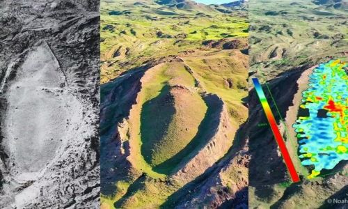
The site was first discovered by map engineer Capt. Ilhan Durupınar in 1959 during a reconnaissance flight to map the eastern Anatolia region in Turkey. The site is located 8 miles south of the Greater Mount Ararat summit at an elevation of about 2,000 meters above sea level. The size and shape of the formation led to its promotion by some believers as the petrified ruins of the original Noah’s Ark.
The “boat formation” appears to be the “exact length” of the ark as written in the Bible – which is around 150 meters, or 300 cubits in Biblical terms.
This is how you shall make it: the length of the ark shall be three hundred amot, its width fifty amot, and its height thirty amot. (Genesis 6:15)
Geologists however claim that the mountainous bump that was discovered half a century ago is nothing more than a unique rock formation.
However, experts have argued such parallel line and right angles below the surface is something you would not expect to see in a natural, geologic formation, … but these results are what you would expect to see if this is a man-made boat matching the Biblical requirements of Noah’s Ark.
In 2021, researchers carried out 3D scans of Electrical Resistivity Tomography (ERT) survey. They claimed to have discovered a man-made boat structure beneath the ground. Next summer, they will carry out a survey using ground-penetrating radar (GPR) technology.
If the new discovery is confirmed, it will prove the historical accuracy of the Biblical account of the flood during the time of Noah which describes the final resting spot of the ark as being in the Ararat mountains.
New technology discovers what appears to be Noah’s Ark, where Bible says it docked
By David Sidman
Reprinted from Israel 365 News
A massive shape that appears to match the Bible’s description of Noah’s Ark has been discovered by archaeologists using 3D scans reports the US Sun.
The researchers used earth-penetrating radar to examine the boat-shaped formation on Mt Tendürek which has long been understood to be the spot where the legendary vessel from the Book of Genesis docked.
so that in the seventh month, on the seventeenth day of the month, the ark came to rest on the mountains of Ararat. (Genesis 8:4)
Joint research
Both Turkish and American researchers have called the initial scans promising and suggest a manmade object underneath the bedrock – and they are optimistic that it may be Noah’s Ark.
Bible scholars have long held that Noah’s Ark was buried under the mountain, known as the Durupınar, in eastern Turkey.
Geologists however claim that the mountainous bump that was discovered half a century ago is nothing more than a unique rock formation.
The team, which is led by long-time ark hunter Andrew Jones, believes that they have acquired images of something that resembles Noah’s Ark.
Not what you would expect to see
The radar surveys were operated at the site by the Oregon-based Topa 3D – who were shocked at the results.
“This is not what you would expect to see if this site is just a solid block of rock or an accumulation of random debris from a mudflow,” Jones told Sun Online.
“But these results are what you would expect to see if this is a man-made boat matching the Biblical requirements of Noah’s Ark.”
The project – Noah’s Ark Scans – say they have found “parallel line and right angles below the surface” which are “something you would not expect to see in a natural, geologic formation”.
The “boat formation” appears to be the “exact length” of the ark as written in the Bible – which is around 150 meters, or 300 cubits in Biblical terms.
This is how you shall make it: the length of the ark shall be three hundred amot, its width fifty amot, and its height thirty amot. (Genesis 6:15)
The site, which is where the Ark rested according to Bible scholars, was initially discovered in 1959 by Turkish army captain Ilhan Durupinar, who spotted the irregular boat formation while snapping aerial photographs of the region for the military.
His discovery resulted in a short-lived period of international intrigue into the site.
The Durupinar site was then visited by controversial researcher Ron Wyatt in the 1970s.
Compelling skeptical geologists to reconsider
His findings favored the location being Noah’s Ark causing other archaeologists, researchers, and scientists to study the formation.
The new team’s breakthrough findings could compel skeptical geologists to reconsider their position.
“It’s a whole new ballgame now. Those judgments dismissing the site were made decades ago and based on limited data compared to what we have now” Ryan Mauro, president of the Doubting Thomas Research Foundation, which is a non-profit organization dedicated to investigating the historicity of Biblical accounts told the Sun.
“Before learning about these scans, it seemed like those who continued to argue in favor of the Durupinar site just couldn’t accept the truth and let it go” he added.
The team intends on carrying out more scans at the site, followed by drilling and eventually excavations.


Leave A Comment
You must be logged in to post a comment.